A Class of Our Own

I grew up on the East Coast: in Northern Virginia right outside of Washington, DC. It’s one of the reasons I came to love mountains. The Appalachian mountains were part of the landscape where I grew up and I could even see the Blue Ridge in the distance from my childhood home.

As I got older, I came to enjoy hiking through these mountainous landscapes – mostly in Shenandoah National Park – where the Appalachian trail runs through North to South (or South to North depending on where you start).

The New River in West Virginia, May 2022. Much like what I was used to growing up, these mountains are like gentle rolling hills with lush vegetation.

I remember reading Bill Bryson’s A Walk in the Woods as a teenager and imagining section hiking the Appalachian Trail, as I had already done a large portion of it. This never came to fruition but I still got to know that trail (at least the central portion of it) pretty well.

This sort of shaped my idea of what hiking was like for many years. I read about the treacherous northern portions of the Appalachian Trail in Bill Bryson’s book but never experienced it first hand. It wasn’t until I was an adult did I venture off to other places with different types of hiking and realize that the mid-Atlantic portion of the Appalachian mountains is pretty forgiving and – for the most part – quite tame.

Hikers generally break terrain up into Classes. These come from a rock climbing scale for difficulty called the Yosemite Decimal System (or YDS). The higher the Class number, the more difficult and dangerous the hike or climb (and Class 5 climbing is what is traditionally known as rock climbing and requires ropes and other specialized gear for safety reasons – of course you can ignore this suggestion if you’re Alex Honnold).

Class 1 is the easiest, and is consists of what most people think of when they go hiking with some hiking boots, a small daypack and some water. It doesn’t require specialized gear and trails are marked clearly. This is also the lowest risk class.

When trails are less clear or route-finding is required, and you may encounter loose terrain called scree (finer grained) or talus (larger rock fields), you’ve reached Class 2. While you may want a map for navigation purposes, you still don’t need any specialized gear here.

Class 3 is also sometimes referred to as scrambling as you typically need to use your hands and feet to traverse this terrain. Sometimes, the route may also be exposed or be close to large dropoffs where a fall could result in serious injury.

Summit attempt in the Sangre de Cristo Mountains in Colorado, July 2017. Rachel is hiking up a Class 2 talus slope up to some Class 3 scrambling which then becomes sections of exposed Class 4 climbing.

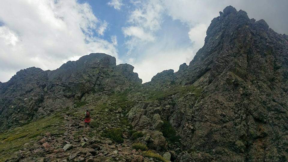
Class 4 is more common for bigger mountains where mountaineering know-how like how to use ropes for crossing sketchier sections is required. The hiking part of Class 4 is typically fairly easy and non-technical; however, there are other factors like a higher level of exposure and the potential for injury on unstable terrain.

As mentioned previously, Class 5 is technical rock climbing and is further divided into sub-levels of difficulty. If you’ve ever been to a rock climbing gym in the US you’ve probably seen the route ratings that also use the YDS.

So getting back to my experiences in hiking, I typically only encountered up to Class 3 hiking in my formative years. Class 4 came onto the scene when I ventured westward to places like Colorado and Wyoming where the mountains are a lot more rugged than the mid-Atlantic Appalachians I experienced. I also rock climb now and have on and off for about six years, so I have a lot of experience with Class 5.

In my next post I want to talk about the differences in what hiking was like growing up and what hiking is like for me now, here in Arizona mostly, as well as the geological reasons for the differences.

Holding Court

This is the second in a series of posts about Zion National Park

Zion Canyon is a canyon through which the Virgin River – a tributary of the Colorado River – runs. All of what I explored during my trip to Zion National Park was in Zion Canyon, only a small fraction of the park itself.

In April, Zion Canyon Scenic Drive – the road through Zion Canyon – is only open to the park shuttle which runs from the Visitor Center (stop 1) in the South to the Temple of Sinawava (stop 9) in the North. Stop number 4 is called the Court of the Patriarchs, after a grouping of rock towers named the Three Patriarchs (after the biblical Abraham, Isaac, and Jacob).

Three Patriarchs (Abraham to the left, Isaac in the center, and Jacob on the right in the background) and Mount Moroni (right foreground).

The Three Patriarchs are composed of a rock unit called the Navajo Sandstone. If you recall the first post in this series – about Checkerboard Mesa – you’ll have heard of Navajo Sandstone. Navajo Sandstone is at least about 200 million years old but may be slightly older and was deposited over a period of about 5.5 million years. It is a sandstone (sedimentary rock) and it is the thickest stratigraphic unit in Zion National Park. The major rock layers are represented by a stratigraphic colum shown below.

Stratigraphic column depicting rock layers that make up formations in Zion National Park. The layers are stacked in order of deposition with the uppermost layers being the youngest (deposited last) and the lowermost layers being the oldest (deposited first). Also depicted are the types of fossils and sedimentary structures that can be found in the units. The diagonal lines in the Navajo Sandstone represent cross-beds. For more information on the Navajo Sandstone and other units see this NPS page from which this column was copied.

As mentioned in the above caption, the Navajo Sandstone is known for its prominent large-scale cross-bedding. So what is cross-bedding exactly? Well, it’s a sedimentary structure (feature of a sedimentary rock) that forms when layers develop at an angle with the primary bedding plane. An example of this in the Navajo Sandstone is given in the picture I took while hiking Angel’s Landing Trail in Zion National Park.

An example of cross-bedding in the Navajo Sandstone along the Angel’s Landing trail. The horizontal lines are the bedding planes and the diagonal lines are the cross-beds. The cross-beds result from sand dunes deposited and shaped by wind flowing right to left in this case.

The Navajo Sandstone represents a remnant of an ancient field of sand dunes in a desert that existed during the early Jurassic – about 200 million years ago. This vast desert landscape extended across the Colorado Plateau region and beyond, approximately spanning from eastern CA to central NM and from Idaho to the Mexico border. This was the largest known sand desert in the history of our planet!

Cross-beds from sand dunes are significant because they tell us about the depositional environment; namely, the direction of transport for the sand grains that eventually formed the rock. For more about this see the diagram below.

A diagram depicting the formation of sand dunes and associated cross-beds. The cross-beds point downward in the direction of wind travel (left to right in this case). Credit: NPS

Stay tuned for more on Zion National Park and its geologic wonders!