Central Arizona is typified by landscapes consisting of flat sandy to rocky expanses interrupted by small mountain ranges and peppered with cacti like the iconic saguaro or the organ pipe variety. To the outsider, it may seem deathly dry and desolate, with a paucity of the life-sustaining substance known as water.
However, the Colorado River, which runs through the iconic Grand Canyon in Northern Arizona makes its way across the desert through its expansive watershed. Near Phoenix, the Colorado River expresses itself – first as the Gila River, and then as the Gila’s largest tributary – the Salt River.
This urban desert oasis offers numerous opportunities for recreation. In fact, it’s quite popular for folks to engage in tubing of the Salt River. Essentially, Phoenix area locals love to grab an inflatable tube and drift with the current along the Salt River to designated drop ins designed for this purpose. I’ve engaged in this activity a couple of times, making new friends and getting pretty badly sunburned.

But last time I went to the Salt River was for the Field Geology class I’m taking this semester. We were there focusing on the Quaternary Geology of Salt River Terraces. Let’s unpack that for a second. First, the Quaternary is a geologic Period. Geologic time spans the age of the Earth (about 4.5 billion years) and within this long time span are Eons. The majority of geologic time occurs during the first three Eons (Hadean, Archaen, and Proterozoic) which are collectively known as the Precambrian. Further subdivisions (Eras) give the Paleozoic, Mesozoic, and Cenozoic, the last of which is most recent. Within the Cenozoic are Periods: the Paleocene, the Neogene and the Quaternary. The Quaternary is the most recent of the Cenozoic Periods and began about 2.6 million years ago. So Quaternary Geology focuses on the most recent 2.6 million years of geologic time (which may seem like a lot but in the grand scheme of things is relatively recent).
The terraces that I mention are landforms that can occur as a result of two different river processes, each resulting in a different type. There are strath terraces, on the one hand, which form when a river cuts laterally into bedrock (in other words, not just cover deposits). Over time, the river abandons its position over which it was cutting into the bedrock and leaves a bench that is composed of bedrock mantled by a thin layer of sediments. The other type of terrace is called a fill terrace and it is a feature that is composed entirely of sediment (a result of an existing river valley being filled with river deposits, or alluvium). Also abandoned, the resulting “bench” is composed of this alluvium.

During my trip, we were out mapping both types of terraces of the Salt River. The fact that the terraces exist tell us that the river evolved through time because we know that terraces result from a river abandoning its former path. Why then, does this happen? Well, let’s begin by discussing the two primary factors in determining a river’s evolution: sediment load and transport capacity. Sediment load is the total amount of sediment that the river transports. It includes what gets dissolved, what is suspended in the water, and what moves along the riverbed through rolling, sliding, and bouncing (known as “bed load”). Transport capacity is the amount and size of sediment that the river has the energy to transport. The energy level of the river is influenced by the water’s velocity and depth, which are controlled by channel slope and dimensions, discharge, and the roughness of the channel.
These two factors determine whether the river will erode through the bedrock, deposit sediment, or dynamically balance those two processes. For example, if the transport capacity exceeds the sediment load, the river has more potential to do work and the sediments being delivered are relatively low, therefore the river will erode. In the reverse scenario, more sediment is being delivered than the river has the ability to transport so the net effect is that sediments get deposited. If the transport capacity is equal to the sediment load, the river is in a state of equilibrium and there is no net erosion or deposition.
Changes in climate, as well as tectonic setting, will affect both the sediment load and the transport capacity but the relationships can be quite complicated. Generally, cooler temperatures are associated with wetter climate and therefore greater transport capacity. Additionally, glaciers are really good at eroding surfaces. In warmer climates, there is generally less precipitation and lower transport capacity so one might see more deposition. It’s not so straight forward, however, and it’s complicated further by the possibility of tectonics changing the overall slopes of the landscapes as well as uplifting land and changing the distance to a river’s local “base level” or the lowest level of an erosional process (an example is sea level).
Anyway, whether it be through climate, tectonics, or some combination of the two, rivers have a tendency to change their positions through time and this is preserved in the landscape in the form of strath and fill terraces and the goal of our field trip was to identify different known terraces (based on age, morphology, and location in the landscape) and map them.
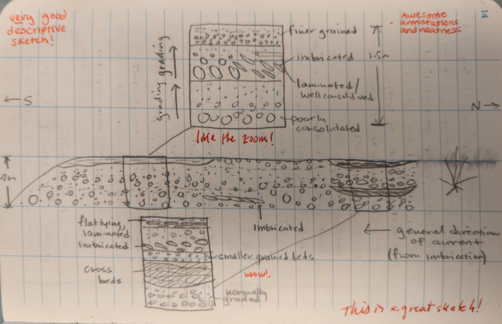
This field trip was useful to me because it helped me to further develop my ability to sketch geologic processes in my field notebook as I thought about them in relation to the geology I was seeing. I’ve often lacked confidence in my artistic abilities, but I’ve been getting more comfortable over time with just accepting that what I produce may not be incredibly photorealistic or even that aesthetically pleasing. Yet, I’ve found that sometimes the best way to record geologic observations is to do a sketch and not worry so much about my expectations of what I think it should look like. That being said, I include one of my field sketches below.
Another important lesson I learned from this field trip was that it is sometimes convenient to work from a model when trying to extrapolate information gained in the field. Basically, if you begin to notice a pattern of where a certain rock tends to be and you don’t have time to cover the entire area of the map you’re trying to produce, you can use your geologic knowhow to make an educated guess as to what rock might be in a place that is difficult or time consuming to reach. I applied this lesson during the field trip, noticing that a lot of times, the terraces contacts with each other tended to follow topographic contours so I was able to fill in certain areas of my map without actually seeing the rock. Sometimes, this worked, and I was correct but other times the model that I had developed in my mind failed me. This reminded me that while models are ultimately useful in a lot of instances, they can potentially be wrong, which I think is an important lesson for a developing geologist.
