Last semester, my students were assigned a project titled “Hometown Geology” in which they were to find (1) a topographic map and (2) a geologic map of an area of interest. They used the maps to learn about the geology of the selected area; specifically, how topography and geology are related as well as identify rock types, geologic features, and reconstruct a geologic history.
One of my students chose the area of Oak Creek Canyon in Sedona, AZ. This student did well on the assignment and little did they know, they were helping me familiarize myself with the geology of area I would soon visit for a hike.
This past Christmas Eve, a couple of friends and I embarked on a journey north of Phoenix to hike Sedona’s tallest peak, Wilson Mountain. One of the friends joining me had one hike left of a Northern Arizona six peak hiking challenge she was unofficially participating in so we chose this hike to do together. It was purely coincidence that one of my students also took an interest in Wilson Mountain, which rises high adjacent to Oak Creek Canyon in Sedona.
Also a coincidence is the fact that the street I grew up on, the first 18 years or so of my life, was called Oak Creek Place. I have fond memories from my youth there on Oak Creek Place and I’m taken back to those memories whenever I’m near Oak Creek Canyon. So I suppose you could say my student’s “Hometown Geology” assignment reminded me of my own hometown.
Oak Creek Canyon is a beautiful river gorge located between Flagstaff and Sedona in Northern Arizona. Oak Creek carved Oak Creek Canyon along the Oak Creek Fault. The Oak Creek Fault is a normal fault that makes it so that the west side of Oak Creek Canyon (the foot wall) is about 600 ft higher in elevation than the east side (the hanging wall). An east-west cross-section through Oak Creek Canyon is shown below. Here you can see how the rock layers have been tilted and offset.
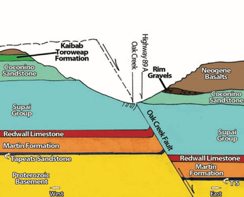
The Oak Creek Fault originally formed about 65-75 million years ago, during a period of compression in western North America. Later (about 25 million years ago), the region began to extend and related to this was outpouring of a series of basalt flows through Oak Creek Canyon along Oak Creek Fault. The fault was later reactivated and offset of these basalt flows occurred.
The mountain we hiked up – Wilson Mountain – is on the west side of Oak Creek Canyon and is higher in elevation due to this faulting activity. The peak of Wilson Mountain rises to a little over 7,000 ft in elevation, which makes for a rewarding hike and great views of Wilson Canyon (south of Wilson Mountain) and its surroundings!

View of Wilson Canyon from Wilson Mountain Overlook. The red colored rocks are the Supai Group sedimentary rocks labeled in the above cross section and the white colored rocks are the Coconino Sandstone. In the foreground are boulders of the Neogene Basalts that cap Wilson Mountain.
