Under Pressure

Last month, I spent a few days in New England. There’s something extraordinary about Fall in a place with four seasons – shortly after I returned to central Arizona, it finally dropped below triple digits!

I flew into Boston and spent a night in Cambridge because I was visiting with a friend from my teenage years/early adulthood who has been living there for a while now. I remember Katrina always wanted to end up in Boston, and I’m happy for her now that she’s successfully built a life there. We spent the evening near the MIT campus, stopping for ice cream at Toscanini’s before dinner because, according to Katrina, “Bostonians love their ice cream and have been reported to consume more of it per capita (especially in winter) than any other place in the United States”. Katrina ordered the goat cheese, honey, and pecan variety, which sounded really good, so I followed her lead. Delicious!

We walked around Cambridge, and Katrina shared facts about the local architecture and pointed out details I wouldn’t have otherwise noted. We walked around looking for a place to eat and landed at an all-you-can-eat hot pot establishment. It was very good, and we were very full. The next day, we walked over the bridge from Cambridge, and I ended up working remotely from a coffee shop on the Berklee College of Music campus – Boston has its share of higher education institutions, no doubt!

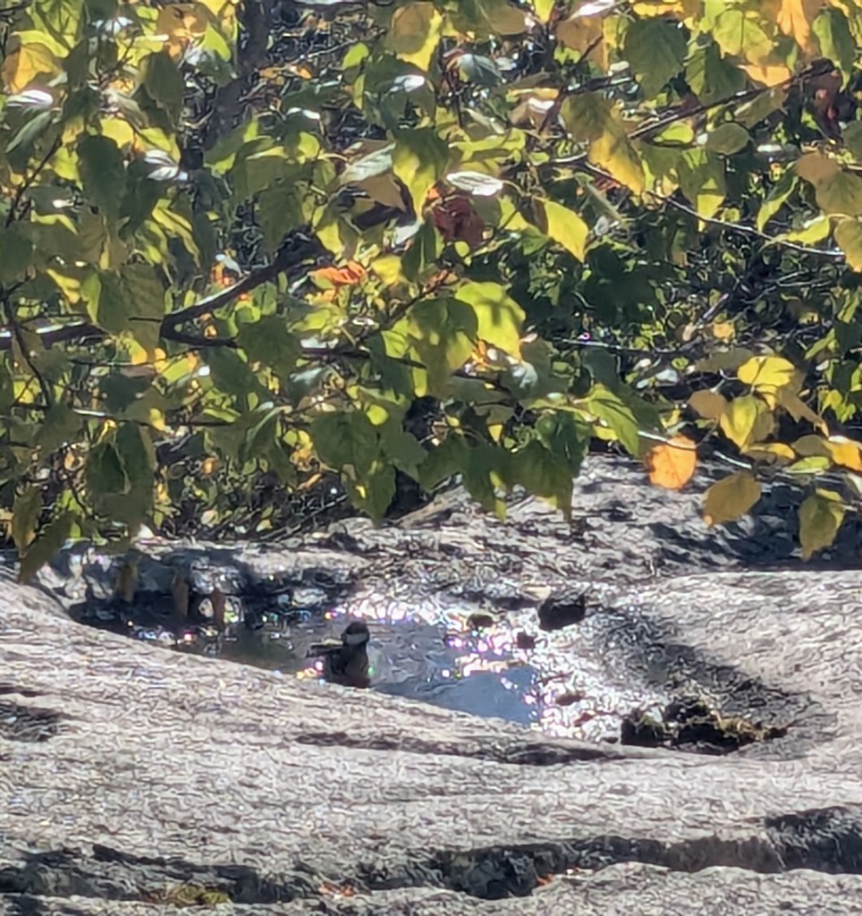
Some friends were joining me for the weekend in New Hampshire, the real purpose of the trip out East. We were to attend a rock climbing festival for women and genderqueer people called Flash Foxy Trad Fest in North Conway. We drove out to New Hampshire together and were to host a climbing meetup for the festival, but it had rained heavily the evening prior, and the rock was quite wet – too slippery for climbing on. Therefore, we decided to hike a short trail called Black Cap, and we saw a BLACK-CAPPED chickadee bathing in a puddle left from the previous night’s rain. 

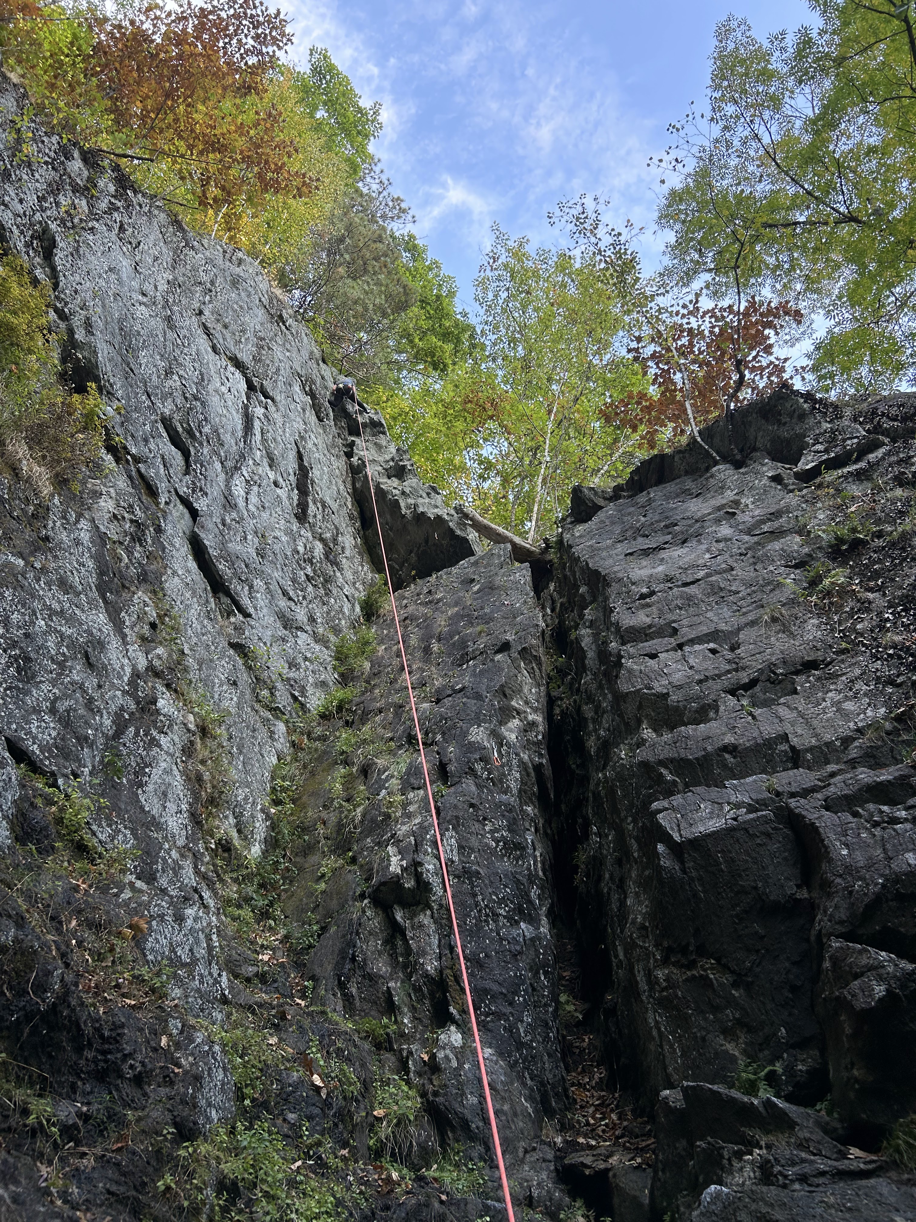
Our plan for the following day was to spend the day doing something called sport climbing (funny, because the festival is called “Trad Fest”, which is a different style of climbing). In sport climbing, a leader uses fixed hardware in the rock to run a rope up the wall and protect other “followers” who wish to climb the same route. Diedre was the leader for all of the routes we climbed that day – an amazing feat and a serious demonstration of skill and courage.

We did several easier routes that day and one more moderate route – not that climbing grades (which denote relative difficulty) are important, or even objective. The “easier” routes were actually a good level of difficulty for me but the “harder” route was a little to much for me in my current state. I decided to bail prior to completing it because I had already made it past the crux – or hardest part of the climb – and I was so exhausted both mentally and physically. I knew it’d be better for my general well being to be able to put myself on more horizontally oriented ground.

I took a much needed break, talked with my mother <3, and enjoyed a short nap. I returned to the crag and finished the climbing day with an easy – but really fun – route called “Shealyn’s Way”. It features a lot of different climbing styles and the route is relatively long for a single pitch (as far as one can go with a 60 meter long climbing rope). I felt all of the uncertainty that I had built up within me from the more difficult climb completely wash away.

The rock we were climbing is called schist. It’s a rock that has been “metamorphosed” under elevated temperatures and pressures which causes changes to it’s crystalline structure. The minerals in the rock orient themselves as a response to the stress that is applied to them and you end up with a rock that records this story of undergoing change under pressure. It’s like when you push down on a ball of play-dough and it flattens into a new shape in response to the applied force.

Metamorphic rocks have always been my favorite of the three rock types (igneous, metamorphic and sedimentary). I think it’s because these rocks record their history of undergoing stressful situations. These “situations” often involve great forces and large-scale dynamism that for me is awe-inspiring and exciting to attempt to comprehend. That storied history literally changes them and that’s what – in my opinion, anyway – makes them beautiful and interesting.

So when I have a tough time climbing a hard route or when I doubt my ability to accomplish hard things, I remember that personal challenges transform me into something also more beautiful and interesting.

Into the Valley of Death

Death Valley does not sound like the name of a place I would want to venture into and yet it’s a place I’ve come to treasure. Death Valley, in eastern California is advertised as the “hottest, driest, and lowest” of the National Parks. It sits in the Mojave Desert and is a valley with mountain ranges on all sides. For example, on the west side there is the Panamint Range and on the east side there is the Amargosa Range.

Death Valley is interesting – geologically – because it is affected by a lot of different tectonic “regimes”. It is dynamically situated at the confluence of the Eastern California Shear Zone (which is associated with the Pacific-North America plate boundary); the Sierra Nevada (large suite of intrusive igneous rock that was subsequently uplifted and tilted); and the Basin and Range (extensional tectonic province spanning western North America).

I last visited Death Valley earlier this year – my brother is living in California and he was taking his first geology class. His school was also offering a field trip to Death Valley over Spring Break and my brother was so interested in his introductory geology course that he decided to attend the field trip, and he invited me!

I drove for a very long time to get there from my home near Phoenix. Arriving after dark, the course participants were all cleaning up following dinner so I set up my tent at the campground and hung out with my brother for a bit before going to sleep.

The next day we decided to explore on our own due to the fact that there were some places we wanted to check out that the course instructors weren’t planning to visit. The weather was also not great – it was actually quite rainy so the “driest” National Park was actually pretty wet. The valley was even filled with water – forming the now ephemeral Lake Manly (a rare occurrence). This was a remnant of the atmospheric river that affected southern California in the early months of 2024.

We had quite the adventure, and saw a TON of lovely geology, which I hope to share more about with you in some subsequent posts. For now I’ll just talk about our first stop, which consisted of a visit to Badwater Basin (and Lake Manly which filled it).

It was my second time at Badwater Basin. The first time I visited was in early March 2020 shortly before the onset of the COVID-19 pandemic. It was actually the last traveling I did prior to everything pretty much shutting down. I was working on a project in the Panamint Mountains that was fully remote so I wanted to visit in-person and get a better sense the geology. I went through Death Valley to get there and stopped at Badwater Basin along the way.

Badwater Basin is considered the lowest point in North America. Although, I met one geologist that argued against this – actually, a very important geologist – David Applegate, the incumbent director of the US Geological Survey. Anyway, the Basin reaches all the way down to 282 feet (85.5 meters) below mean sea level. It is a salt flat comprised mostly of sodium chloride (standard table salt) but also includes other evaporites (or sediments that form from evaporated solutions of water and dissolvable minerals).

The action of this hydration and evaporation of salts generates interesting polygonal geometries that are similar to cracks that form in a layer of dried out mud, for example. These cracks are very interesting in that their form (shape and size) are variable and dependent on things like the swell and shrink potential of the material (how much water it can hold), the rate of evaporation, and the temperature of evaporation.

Badwater Basin with salt polygons from March 2020.

Anyway, all of this makes for a very beautiful landscape when the ground is dried out. Of course, it wasn’t the second time I was there. The landscape was beautiful in a different way though – the flat, fairly still water reflected the surroundings like a foggy mirror. Simply surreal.

Lake Manly filling Badwater Basin, the water reflects the Panamint Range to the West.

Connecting the seemingly unconnected

About a year ago, my grandmother was on her death bed and some of my family got together at my uncle’s house in San Diego, CA, where my grandmother had been living since my grandfather passed away. During this somber time, my cousins and I found solace in thumbing through my grandmother’s photo albums that she created over the years of her life. Within them we found letters, postcards, brochures and tickets from her and my grandfather’s travel, and – of course – photos of all of us as small children. It was bittersweet: the photos captured found memories of our youth, but we also reflected on the loss of innocence that occurs with age.

I realized that there was something about holding the albums full of photos and various artifacts lost in today’s digital world. I decided I wanted to follow after my grandmother and start scrapbooking my life’s events, a sort of “analog” version of social media that has become such an integral part of most of our lives.

Taking things back in this way has helped me realize some things, like how I have a certain type of creativity that I don’t always get to explore – by making something just for the sake of making it – or how one terrible photo can jog a memory of a significant event just as well as (if not better than) ten beautiful ones. I find it as a way to do something useful with all of the personal artifacts I’ve been collecting over the years and in turn, reduce my clutter. I’ve also lovingly shared stories and memories with friends and family as they look through my creations.

Anyway, last weekend I was scrapbooking a trip to Europe I took last summer and I thought I’d write about it here.

In Late August 2022, I attended a workshop in Hévíz, Hungary called the Ada Lovelace Workshop on Modeling Mantle and Lithosphere Dynamics. The meeting’s namesake, Ada Lovelace, is commonly credited with being the first computer scientist because she recognized the potential for mechanical analytical machines beyond pure calculation and was to come up with what would later be considered the first computer program.

The Workshop, named in honor of Lovelace in 2020, is held every two years in different locations throughout Europe and last year it was held in the town of Hévíz, Hungary. This location is known for thermal Lake Hévíz – the second largest “thermal lake” in the world and the largest one with temperatures suitable for swimming.

What makes Lake Hévíz a thermal lake? Hungary is situated in an area known as the Pannonian Basin. This basin resulted after smaller continental fragments collided with the European continent. Starting at about 17.5 million years ago and continuing for about 10 million years – during the middle-to-late Miocene – basins formed behind the Carpathian Mountains as the continental crust extended up to 100 km in an East-West direction. The depth of this extension varied with distance from the Carpathian Mountain range.

Digital terrain model of the Pannonian Basin and surrounding area [source].

Researchers posit that southward (and eastward) migration of the extensional zone occurred and the most internally situated portions of the basin were associated with the greatest depths. That is, the inner basin formed from extension of the entire lithosphere (the crust and uppermost mantle)!

Image Source

When the lithosphere extends in this way, it is thinned out and the deeper, hotter mantle “domes” and becomes situated closer to the surface. Even stranger is that lithosphere of the Pannonian Basin is about two times hotter than would be expected from these types of extensional processes alone. The paper cited attributes this extra thermal energy to “unknown processes in the lower lithosphere”. A more recent paper suggests that the higher modern temperatures are due to the fact that sediments that subsequently filled the basin are good insulators of the hot rocks at the base of the basin. In other words, cooling due to exposure at the surface has been significantly slowed. This has resulted in geothermal gradients (increases in temperature with depth) of up to 50°C/km in the uppermost 5 km of the crust. That’s about two times the global average.

What I found most interesting while looking up the geology of the Pannonian Basin was the tectonics that resulted in its formation. The tectonics of this area is related to the overall mountain building period associated with the formation of the Alps: The Alpine Orogeny. The Alpine Orogeny is linked to the Himalayan-Tibetan Orogeny (the mountain building period resulting in the formation of the Himalayan Mountains and the Tibetan Plateau). They are associated because they began around the same time and resulted in the closure of an ancient ocean known as the Tethys Ocean. Further, there are similarities in the respect that there are large-scale extensional features that form in a dominantly convergent setting. The discovery of this for the Himalayan system was groundbreaking, and actually involved my PhD dissertation advisor.

I think that has influenced what I find interesting and important when learning about the geology of new places. I often link what I find to what I’ve become most familiar with during my studies. I’ve written it before here, but I’ll say it again: “the best geologist is the one who has seen the most rocks”. Because I think it’s human nature to relate what one has experienced in the past to what one is experiencing for the first time.

The power to connect the seemingly unconnected.

William Plomer

The writer William Plomer described creativity as “the power to connect the seemingly unconnected.” If it is in fact very human to relate past experiences to new ones, everyone is creative and whether it be scrapbooking a trip I took almost a year ago, learning about the geology of a new place and connecting it to something I’ve spent years learning about, looking at spreadsheets full of model-derived data trying to see if any patterns develop, or even writing this blog: I get to be creative every single day.

Creativity is exactly what science is to me. As I learn more about geology, I learn more about the ways in which different physical systems that contribute to shaping our planet depend on each other, in sometimes unexpected ways. As part of my dissertation research, I’m seeking to learn how to determine the specific ways a single parameter, for example, effects how we interpret an entire complex model of the earth. In essence, I’m trying to disentangle a web of interdependent physical parameters and processes and in doing so, understand how they all fit together in the first place. By Plomer’s definition then, my science is nothing other than an act of creativity.